Clustered Villages and Scattered Farmsteads on a County Map
Learn to distinguish clustered villages from scattered farmsteads on a county map, compare their layout fairly, and describe each pattern clearly.
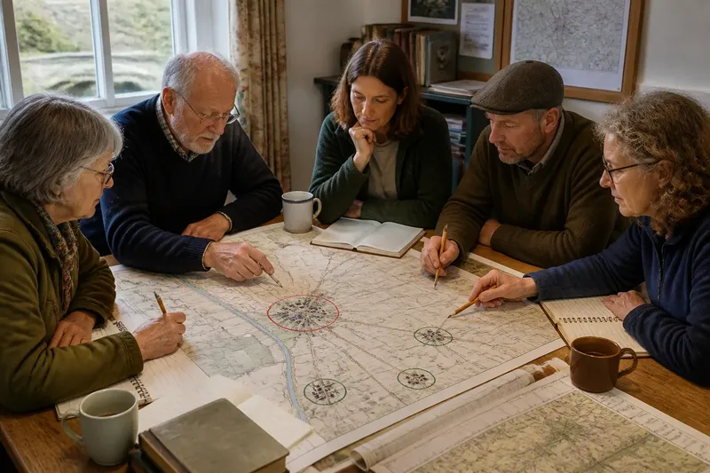
A tight knot of house symbols beside a church can look like the obvious center of a county map. A few miles away, homes and barns may appear singly along winding lanes. Clustered and scattered settlement patterns describe these different layouts, and a careful comparison shows how buildings relate to roads, fields, and one another.
Imagine a hypothetical county called Bellwether, where a local history group compares Mill End with a neighboring farm area. At Mill End, buildings gather around a square near a stream crossing; across the parish boundary, houses and barns stand apart among fields. The group wants to describe the contrast while noticing how each settlement’s buildings and routes fit together.
Settlement pattern types
A clustered settlement concentrates homes and other buildings in a compact area. Buildings may gather around a village green, line a main street, or sit near a crossroads or bridge. The layout describes where structures are, not why they gathered there.
A dispersed settlement spreads homes across a larger area, often among farms, outbuildings, and lanes. A farmhouse with nearby barns forms a small building group, but it may remain well apart from other farmsteads. Such spacing describes the settlement layout; it does not establish how residents interact or travel.
These patterns are not rigid categories. A compact village can have outlying farms, and a dispersed district can include several small clusters. State which part of the area you mean rather than assigning one label to a whole county or parish.
Compare buildings and routes
To compare settlement patterns, look beyond the number of symbols. Notice whether buildings form a continuous concentration, how that concentration relates to streets or lanes, and where it thins into open land. For dispersed areas, note repeated gaps between building groups and how routes connect them.
- If buildings form a sustained knot around a street or green, describe a clustered core; if only a few stand together, check nearby lanes before calling it a village center.
- If farmhouses have barns close by but other farmsteads remain separated, describe small groups within a dispersed pattern; if groups connect into a continuous built-up area, describe the denser section separately.
- If lanes pass through a dense building group, note the route’s relationship to the settlement; if a road junction has few nearby buildings, describe it as a junction rather than a settlement center.
- If open fields clearly separate one building group from another, describe the gap and the groups on either side; if the map does not show field detail, avoid inferring the land use from spacing alone.
- If a cluster fades gradually into outlying homes, describe its edge as a transition; if a clear gap separates the homes, identify them as outlying rather than extending the cluster without qualification.
- If the map shows building types or names, use those labels when describing the pattern; if it shows only general symbols, call them buildings rather than assuming each is a home or working farm.
For Mill End, the Bellwether group marks the cottages, church, pub, and shops around the square, then traces the lanes leaving the built-up area. In the farm district, it notes separate building groups along those lanes and the open spaces between them. This comparison describes the arrangement and its visible transitions, rather than ranking one pattern as more important.
Map scale and symbols
Map scale affects how much detail appears. A county map can help compare broad patterns across a large area, while a detailed local map may show individual lanes and building groups. A small-scale map often simplifies features, so an apparently empty patch may have more detail on another map.
Symbols also shape what a reader can say. A map may mark a named settlement without showing each building, or use one symbol for structures that serve different purposes. Check the legend and map date, and keep those limits in mind when comparing places.
For a fair comparison, use maps with similar coverage and detail where possible. If one map marks every farm building and another shows only named villages, describe the difference in mapping as well as the visible settlement pattern.
Questions about patterns?
How can I tell a cluster from nearby farms?
Look for a sustained concentration of buildings, not just two or three symbols in the same vicinity. Compare its street layout and outer edge with the spacing beyond it; if the concentration does not continue, describe a small group rather than a village core.
Can one place have both patterns?
Yes: a compact village can sit within a wider district of separated homes and farms. Describe the village core and the outlying buildings as distinct parts, then note the lanes or open spaces between them.
Which map scale should I use?
Use a county map to compare broad patterns and a more detailed local map to inspect individual streets and building groups. If the map omits the features your question depends on, choose a more detailed source or narrow the description to what it does show.
Does the layout explain why people settled there?
No. A map can show buildings near a crossing or spread among fields, but layout alone does not establish the cause. Historical maps and local records may help address settlement origins; distinguish those sources from what the current map depicts.
A worked comparison
Say the Bellwether group has a county map showing Mill End, the neighboring farm area, their roads, and building symbols. The group first checks the legend, then marks the compact knot around Mill End’s square and the separated groups along the farm lanes. It records the bridge near the square as a visible route feature, not as the proven reason the village formed there.
Next, the group compares the two areas at the same map detail. It sees a clear concentration in Mill End and repeated gaps between farm groups in the neighboring area, so its account calls the first a clustered village and the second a dispersed farm district. If a more detailed map later reveals small clusters within that district, the group can add them without changing the broad comparison.
The group’s resulting description is specific: buildings gather around Mill End’s square and thin along the lanes, while farmsteads in the neighboring area remain separated by open land. The map supports those observations, but not claims about residents’ routines or the historical cause of the layouts.
What symbols cannot show
Building symbols may not distinguish a home from a barn, an empty structure, or a building used only seasonally. Spacing alone also cannot show whether neighbors share services, travel together, or identify with the same village. Use a different source, such as local records or a detailed land-use map, if those questions matter.
When reading clustered village and scattered farmstead patterns on a county map, name the building arrangement, its relation to routes, and the map’s level of detail. This lets a reader compare the visible geography without mistaking a road junction for a center or a simplified map for a complete inventory.