Why Valleys Make Natural Guides to a County
Valleys offer a way to trace how county streams, tributaries, and neighboring lowlands connect, while keeping natural terrain distinct from administrative borders.
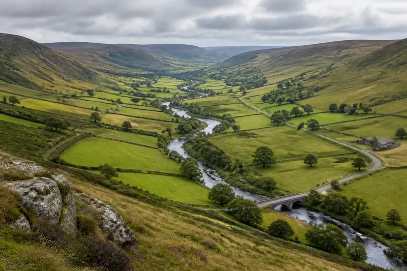
On a county map, a blue stream may curve past a village and disappear beneath a road. Following the valley around it helps you see how water gathers from neighboring slopes and where the low ground continues beyond the stream’s bends. A valley is a natural guide to a county’s drainage connections, not a line that defines the county.
Valleys and drainage
A valley is a low area between higher ground, often shaped by a stream or river. Its most useful map clue is how its channels connect: small tributaries join larger ones, which carry water toward an outlet.
A watershed is the land area that drains to a particular outlet. Ridges separate watersheds, so water falling on opposite sides of a ridge can travel into different valley systems. This distinction makes a valley useful for tracing a channel, while a watershed describes the larger area feeding it.
Begin with the stream network rather than trying to outline the valley’s full shape. Follow the main channel, note where side streams join, and look for ridges that divide one drainage route from another. Some low corridors have no clearly mapped stream, and a stream may not flow year-round.
Following the water
Tributaries are smaller streams that flow into a larger channel. Their junctions show how water from different slopes gathers. On a map, branches may meet at sharp or shallow angles; the pattern helps connect nearby slopes to a shared route without, by itself, explaining how the landscape formed.
To infer which way a stream flows on a topographic map, look where contour lines cross its channel. The contours’ V shapes generally point uphill, so water flows in the opposite direction. Check the legend and contour interval, since symbols and terrain detail differ among maps.
Blue marks need interpretation, too. A map may use different symbols for perennial streams, which flow throughout the year, and intermittent channels, which flow only at certain times. The legend tells you what the mapmaker intended each mark to represent.
Reading connected valleys
A main valley may gather several side valleys before reaching a larger river or leaving the county. That branching arrangement can make a county map easier to read as a set of connected drainage routes rather than isolated blue lines. The stream network is the focus here: roads and buildings may sit nearby, but they do not determine how water drains.
Imagine an invented county map with a creek running south and two smaller channels joining it from the east. The creek then crosses the county line and meets a larger river beyond the map’s edge. Trace each channel from its headwaters to its junction, then mark the ridge between the eastern branches; the resulting reading is that both side channels feed the creek, while the ridge separates their upper slopes from land draining elsewhere.
At a small map scale, short tributaries may be omitted and bends simplified. A larger-scale topographic map can show more local detail, while a regional map can clarify where the county’s streams fit into a larger river system. Use the map’s scale and legend to judge how much detail it can reasonably convey.
Valley floors and slopes
A valley’s cross-section is its shape from one side to the other. A narrow valley may have steep sides and little flat ground beside the channel; a broad valley may include a wider floor and gentler slopes. These shapes affect how much of the surrounding terrain is visible as a connected low corridor.
Contours help reveal relief, but the drainage pattern offers a different question: which slopes feed which channels? Compare the tributary locations with the higher ground between them. This can clarify why two streams that look close together on a map may drain in different directions.
A terrace is a relatively level bench above the present valley floor. It may appear as a flatter strip between the channel and rising ground. A map can help locate such a landform, but confirming its character may require more detailed local information.
Routes near water
Roads, rail lines, and trails sometimes follow valley corridors, but their alignment does not reveal the drainage system on its own. A road may parallel a stream briefly, cross it, or climb away toward another destination. Trace the channel and route separately before comparing them.
Where a road crosses a stream, the map shows a connection between the route and the channel at that location. It does not establish why the crossing was placed there. Terrain, access to nearby places, and other local decisions may all matter, so treat the map as a record of arrangement rather than a complete account of cause.
County lines and valleys
A county boundary may follow a stream or valley for part of its course, but a natural lowland is not automatically an administrative border. The stream may meander across the valley floor while the county line takes another route, or the two lines may coincide briefly.
Check the map legend and trace the boundary and stream independently. For the legal or official location of a county line, use an authoritative boundary map; use a topographic map to understand the land and drainage. Keeping those sources distinct prevents a physical feature from being mistaken for an administrative rule.
Questions about valley maps?
What is the difference between a valley and a watershed?
A valley is a low area between higher ground, often containing a channel. A watershed is the entire area that drains to a chosen outlet, including ridges, slopes, and potentially several valleys.
How can I tell which way a stream flows?
On a topographic map, contour lines crossing a stream form V shapes that generally point uphill. The stream flows downhill in the opposite direction; check the legend and contour interval before drawing a conclusion.
Does every valley have a river?
No. A valley may contain a small stream, an intermittent channel, or no mapped surface water. Its low shape can still help explain how nearby slopes and drainage routes are arranged.
Why do streams join in branching patterns?
Tributaries carry water from smaller drainage areas into larger channels. Their junctions show how separate slopes connect to a shared route, though a map alone may not explain the pattern’s origin.
A useful map sequence
Use this sequence to keep attention on drainage connections. For each item, compare the observation with the decision that follows; if the map is unclear, use the alternative rather than forcing a reading.
- Check the legend for channel symbols. If it distinguishes intermittent channels, treat them as seasonal or occasional drainage; if it does not, consult a more detailed map instead of assuming year-round flow.
- Check where tributaries meet the main channel. If a side channel joins it, trace that branch as part of the same drainage network; if no junction is shown, avoid assigning it to that channel without clearer mapping.
- Check contour V shapes at a stream crossing. If their points face upstream, infer flow in the opposite direction; if the contours are too sparse or unclear, leave flow direction unresolved.
- Check the higher ground between neighboring channels. If a ridge separates them, treat it as a likely divide between drainage areas; if the ridge is not apparent, compare a more detailed topographic map.
- Check where the channel exits the map. If it continues beyond the county, follow it onto a regional map; if the mapped edge cuts it off, do not treat the edge as the stream’s outlet.
- Check the map scale and contour interval. If the map omits small channels or smooths bends, use it only for broad connections; if local detail matters, switch to a larger-scale map.
- Check the boundary symbol separately from the water symbol. If both follow the same route, note their overlap only for that stretch; if they diverge, read each line according to its own legend.
When using county geography as a guide, follow the valley’s channels and divides to understand how water connects across the landscape. A stream that crosses a county line is a reminder that drainage systems do not stop at administrative borders, and the regional map beyond the county may complete the story.