When a County Line Moves on the Map
When a county line moves on the map, compare official records, older maps, and local connections to explain what changed and what stayed familiar.
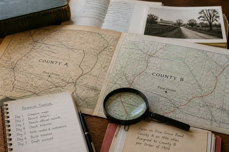
A road atlas puts a farm in one county, but an older courthouse map places it in the next. To understand when a county line moves on the map, trace the official record alongside the routes and institutions that connected nearby residents.
Compare county maps
Start with a current county map and an older map of the same area. County atlases, library map collections, local archives, and government geographic-information portals can help. Note each map’s publication date, publisher, and purpose: a road map, tax map, and historical atlas may depict the same boundary differently.
Choose landmarks visible on both maps, such as a courthouse town, river crossing, or named road junction. Compare the line near those landmarks, but keep the map’s function in mind. A different-looking line might reflect how the map was drawn rather than an official change in jurisdiction.
Identify the boundary
County boundaries assign places to government units for particular administrative purposes. Regional identity describes how people relate to a landscape, town, or community. The two can overlap, but neither tells the whole story of the other.
In your notes, separate the county shown on a map from the names people use for the surrounding area. Avoid saying “the district moved” if the evidence only shows that a parcel was assigned to a different county. Precise wording makes clear whether you mean a government decision, a changed map depiction, or a local identity.
Read official records
Look for legislative records, boundary descriptions, county histories, and local government archives. An official action or boundary description can establish whether a transfer was authorized. A history may explain the circumstances, while a later map can show how the new line was depicted.
Some apparent changes are not transfers. A stream may shift, an old description may be clarified, or a mapmaker may place a line more accurately. Look for wording that identifies whether the record concerns a jurisdictional change, a survey, or a revised depiction.
Administrative changes can involve services, representation, jurisdiction, or the practical organization of territory. These are possible explanations, not a conclusion about any particular boundary. The relevant records should identify what applied in the area you are examining.
Follow local ties
County lines do not necessarily match the routes people take for court, trade, school, worship, or postal service. Roads, local organizations, and familiar town centers can connect residents across an administrative boundary. Local histories, newspapers, and oral-history collections may help describe those ties, while individual accounts should not be treated as everyone’s view.
Say you are tracing a hypothetical farming community. An older map places its farms in County A, and a later official record assigns them to County B; both maps show the same road leading to a trading town in County A. Your timeline would record the new county assignment, while the mapped road supports the narrower observation that the route to that town remained visible. It would not establish how every resident felt about the change.
Questions about county lines?
Does a different map prove the line moved?
No. Maps can simplify a boundary or use different source material. Look for an official action or boundary description before calling a difference a county transfer.
Why might officials change a county boundary?
Possible reasons include reorganizing administration, clarifying jurisdiction, or adjusting representation and services. Records for the specific area determine which explanation applies.
Can residents keep an older regional identity?
Yes. A county assignment and a sense of local belonging address different questions. Local accounts may show how some people described their area without establishing a single identity for everyone.
Which source should I consult first?
For whether a change was officially authorized, begin with the relevant law, boundary description, or government record. Use maps to examine how the line was shown and local accounts to explore community connections.
Build a seven-day account
Use one focused task each day, keeping the notes together so that the final account distinguishes administrative changes from local connections.
- Day one: Gather a current county map and an older map. If both identify the same landmarks, compare the line near them; if not, seek a map with clearer shared reference points.
- Day two: Record each map’s date, publisher, and purpose. If those details are available, note them beside the map; if not, mark the map’s provenance as uncertain and avoid relying on it to date a change.
- Day three: Search for a law, boundary description, or government record. If it documents an authorized change, record its date or period; if it does not, do not describe the map difference as a confirmed transfer.
- Day four: Check county histories and local archives for an explanation. If a source names a reason, attribute the explanation to that source; if none does, leave the reason unresolved.
- Day five: Note visible routes and local institutions, such as roads to a town or a courthouse. If the sources support a connection, describe it specifically; if they do not, avoid making claims about residents’ routines.
- Day six: Create a timeline with columns for date or period, administrative record, and map or local account. If a date is documented, enter it with its source; if it is missing, leave the cell blank rather than infer a date from a later map.
- Day seven: Draft a short account separating documented facts from unresolved questions. If the record supports a transfer, state the assignment and cite the source in your notes; if authority or timing remains unclear, say so and consult the relevant government office or a qualified local historian when practical consequences matter.
For a fully worked hypothetical timeline, suppose an older map labels a farm in County A, a later government record says the farm was assigned to County B, and a subsequent map shows the County B line. On day one, you compare the maps at the same road junction; on day two, you record their dates and purposes. On day three, you enter the government record’s stated period as the supported administrative change; on day four, you find no documented reason and leave that question open. On day five, you note that the road still leads toward the same town on both maps; on day six, you place the record and maps in separate timeline columns. On day seven, the answer is limited but clear: the farm’s county assignment changed according to the record, the route to the town remained depicted, and the reason for the change is unresolved.
Write with precision
In your final account, name the county assignment, the record that supports it, and any uncertainty about timing or local response. If an official description controls a practical or legal matter, consult the relevant government office or a qualified local professional rather than relying on a map comparison.
A careful account of when a county line moves on the map can show both the government’s jurisdiction and the local connections visible in the sources. Those are different kinds of information, and stating each on its own terms gives readers a clearer picture of what changed.