Compare Neighboring Counties With Two Maps
Compare neighboring counties with two maps, using shared borders and named features to record clear differences without mistaking map symbols for proof.
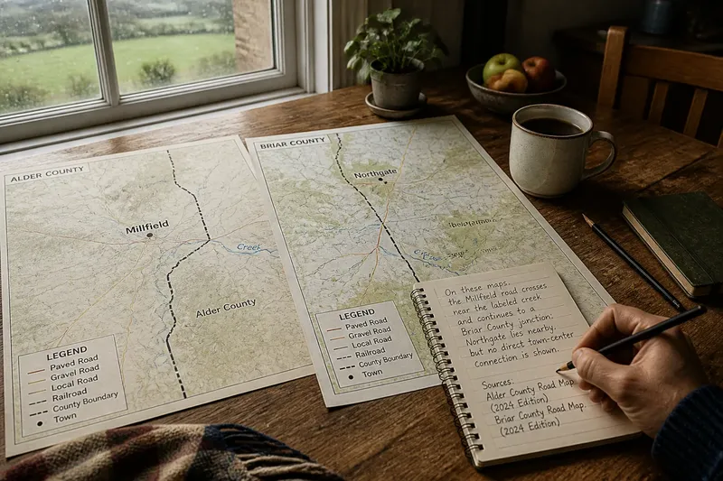
Two county maps on a kitchen table can reveal a useful contrast: a town label may sit close to the shared boundary on one sheet, while the nearest labeled town on the other lies farther away. Comparing neighboring counties with two maps works best when you track named places and boundary crossings, rather than trying to explain every curve or landform.
A Two-Map Plan
Set aside one afternoon to produce a short, checkable comparison. Use the first part to choose and align maps, the middle to inspect the same boundary stretch, and the final part to write down one contrast with its location and source.
- Check the map titles and coverage; if each map includes the shared county line, use the pair, but if one cuts off the border, choose another map.
- Check the scale bars; if they represent the same ground distance in the same map space, compare distances visually, but if they differ, use maps with matching scales.
- Check the legends for the feature you want to compare; if both use the same symbols for towns or roads, proceed, but if not, compare a feature with a shared convention or find a better-matched pair.
- Check the publication or update details; if the maps are close enough in date for your question, continue, but if one shows a newer boundary or settlement pattern, seek a current pair.
- Check that the shared boundary is visible on both maps; if it is, select a stretch present on each, but if not, change the map extent before comparing.
- Check whether labels overlap or obscure the feature; if the locations remain readable, record them, but if not, zoom in or consult a clearer map.
Align the Shared Edge
Choose a stretch of the county boundary that appears on both maps. A paper map can be turned so the shared line runs in the same direction on each sheet; in an app, use the same map style and zoom, then keep the visible boundary segment consistent.
Do not compare one county’s entire map with only a small corner of its neighbor. Instead, look at a similar band on either side of the line, or choose a pair of named places near the boundary and follow how they connect across it.
A county boundary is a line used to define administrative territory. It does not necessarily mark a change in the landscape, local identity, or everyday travel, so treat it as a reference for locating features rather than an explanation by itself.
Trace Named Connections
Give attention to features that can be identified on both maps: towns, road junctions, rivers with labels, bridges, or rail lines. Record whether a road crosses the county line, ends at it, or meets another route nearby. This describes a mapped connection without making assumptions about traffic or travel conditions.
Named places help keep the comparison specific. A note such as “the road from Millfield crosses the boundary near the labeled creek” is easier to check than “the counties have different road patterns.” If the map does not name a place, use a nearby junction or another visible reference point.
Compare how the same kinds of connections appear on each side. A road that continues across the line on one map and a route that approaches but does not visibly cross on the other may be a useful contrast, provided both maps show roads with comparable detail.
Work Through One Comparison
Imagine you have two current county road maps at the same scale: one for fictional Alder County and one for fictional Briar County. Both show the shared boundary, Millfield in Alder County, Northgate in Briar County, and a labeled creek where the county line bends.
First, check each legend and confirm that the same line style represents paved local roads on both maps. Next, trace the road from Millfield toward the county line: it crosses near the creek and continues toward a junction in Briar County. Then trace the road from Northgate toward that same boundary stretch: it also reaches the junction, but the map does not show a direct route from the town center to the crossing.
The resulting note could read: “On these maps, the Millfield road crosses near the labeled creek and continues to a Briar County junction; Northgate lies nearby, but no direct town-center connection is shown.” The observation is specific and checkable. It does not establish whether a connection exists off-map, how busy the road is, or why the route was laid out that way.
Map Limits?
Can I compare maps from different publishers?
Yes, if their coverage, scale, date, and symbols suit the feature you are comparing. Read both legends because matching colors or line styles can represent different things.
What if one map has more labels?
Use only features that are legible and represented on both maps. If the difference in detail prevents a fair comparison, find a more comparable map rather than treating missing labels as missing places.
Can a map show why a boundary bends?
A map may show nearby rivers, roads, or settlements, but their presence does not establish why the line was drawn. For the boundary’s history, consult a reliable local history or official boundary record.
How should I record a feature I cannot identify?
Describe its symbol and location, then check the legend or map notes. If it remains unclear, leave it out of the comparison or mark the interpretation as uncertain.
Write a Checkable Note
Keep the final note to three elements: the feature, its location, and the visible relationship. Include the map titles or editions so another reader can locate the same evidence, and separate what the map shows from any explanation you are considering.
Comparing neighboring counties with two maps is most useful when the final claim stays narrow. A named crossing or junction gives you a firm point of reference; the map’s limits tell you what still needs another source. That distinction makes even a small observation more useful than a broad judgment about either county.